| |
Welcome to the | |
| |
AACES-2 Project | |
| Australian Airborne Cal/val Experiment for SMOS |
|
Home page
Google Earth (KML file) Workplan SMOS AMSR-E WindSat ASCAT PALSAR ASAR MODIS MTSAT-1R ASTER Landsat CHRIS AVNIR-2 PLMR data Thermal Infrared data Multi-Spectral data Monitoring stations Soil moisture sampling Vegetation sampling Campaign shapefiles DEM Land use Climate data Soil classification Soil water capacity Soil texture analysis AACES homepage Moisturemap homepage |
 Source: http://www.cpi.com, accessed on 28th, Apr. 2010
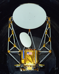
WindSatWindSat is a multi-frequency polarimetric microwave radiometer with similar frequencies to the AMSR-E sensor, with the addition of full polarisation for 10.7, 18.7 and 37.0GHz channels and the lack of an 89.0GHz channel. Developed by the Naval Research Laboratory, it is one of the two primary instruments on the Coriolis satellite launched on 6th January 2003. WindSat is continuing to outlive its three year design life, with data free of charge to scientists from here. WindSat data can be downloaded from NRL.
WindSat overpass timeWindSat coverage for the Murrumbidgee Catchment during the AACES-2 campaign has been calculated by a Fortran program based on NORAD data for 29th, Aug. 2010, and is summarized in the table below. Date and time are in UTC. Aircraft flights were assumed to be conducted at 7:45 for descending overpass and 20:35 for ascending overpass.
|
|||||||||||||||||||||||||||||||||||||||||||||||||||||||||||||||||||||||||||||||||||||||||||||||||||||||||||||||||||||||||||||||||||||||||||||||||||||||||||||||||||||||||||||||||||||||||||||||||||||||||||||||||||||||||||||||||||||||||||||||||||||||||||||||||||||||||||||||||||||||||||||||||||||||||||||||||||||||||||||||||||||||||||||||||||||||||||||||||||||||||||||||||||||||||||||||||||||||||||||||||||||||||||||||||||||||||||||||||||||||||||||||||||||||||||||||||||||||||||||||||||||||||||||||||||||||||||||||||||||||||||||||||||||||||||||||||||||||||||||||||||||||||||||||||||||||||||||||||||||||||||||||
|
Created: September 2010 Last Modified: September 2010 Maintainer: YE Nan, Ye.Nan@monash.edu |