| |
Welcome to the | |
| |
AACES-2 Project | |
| Australian Airborne Cal/val Experiment for SMOS |
|
Home page
Google Earth (KML file) Workplan SMOS AMSR-E WindSat ASCAT PALSAR ASAR MODIS MTSAT-1R ASTER Landsat CHRIS AVNIR-2 PLMR data Thermal Infrared data Multi-Spectral data Monitoring stations Soil moisture sampling Vegetation sampling Campaign shapefiles DEM Land use Climate data Soil classification Soil water capacity Soil texture analysis AACES homepage Moisturemap homepage |
Experiment OverviewBy the end of the commissioning phase of SMOS a decision was made by ESA to continue measurements in full polarisation mode only, with sky calibrations conducted fortnightly. A validation of the satellite performance in operational mode was required for the initial part of the operational phase, for a range of diverse soil moisture and land cover characteristics. The AACES-2 campaign was able to meet these requirements, because of its location in the southern hemisphere and that the campaign was designed to cover a large transect with significant variability in conditions. The second AACES field experiment focused on the central half of the 100km × 500km (initially more than 20 independent SMOS pixels) transect of the Murrumbidgee River catchment previously covered during AACES-1 at 1 km resolution using an L-band radiometer, with flights timed to coincide with SMOS overpasses. The primary airborne instruments included the Polarimetric L-band Multibeam Radiometer (PLMR), thermal infrared and multi-spectral sensors, supported by surface soil moisture content, soil temperature and rainfall data from the Murrumbidgee (OzNet) monitoring network. This was further complemented by short-term soil moisture and temperature monitoring stations with supplementary rainfall, leaf wetness, and thermal infrared measurements. In addition, intensive near-surface soil moisture sampling using the Hydraprobe Data Acquisition System (HDAS) and extensive vegetation characterisation were conducted at a number of focus farms. Murrumbidgee Catchment 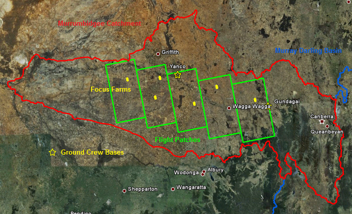 Source: GoogleEarth, accessed on 28th, Apr. 2010 (modified)
An overview of the AACES-2 campaign is provided in a KML file that can be opened by Google Earth software. All data collected during the AACES-2 campaign can be downloaded via the Download Centre. AACES-2 field campaign schedule
Reconnaissance:
Surface roughness measurement, gravimetric soil sampling, set up/ removal of temporary monitoring stations SM sampling: HDAS soil moisture measurements, classification of land cover, canopy height, surface rock cover Veg sampling: LAI and ASD measurements, destructive vegetation and dew sampling. |
||||||||||||||||||||||||||||||||||||||||||||||||||||||||||||||||||||||||||||||||||||||||||||||||||||||||||||||||||||||||||||||||||||||||||||||||
|
Created: September 2010 Last Modified: September 2010 Maintainer: YE Nan, Ye.Nan@monash.edu |
