| |
Welcome to the | |
| |
AACES-1 Project | |
| Australian Airborne Cal/val Experiment for SMOS |
|
Home page
Google Earth (KML file) Workplan SMOS AMSR-E WindSat ASCAT PALSAR ASAR MODIS MTSAT-1R ASTER Landsat CHRIS AVNIR-2 PLMR data Thermal Infrared data Multi-Spectral data Monitoring stations Soil moisture sampling Vegetation sampling Roughness sampling Campaign shapefiles DEM Land use Climate data Rainfall data Soil classification Soil water capacity Soil texture analysis AACES homepage Moisturemap homepage |
Experiment OverviewFor the first AACES field campaign, AACES-1 (18 January to 21 February, 2010), 5 weeks were required to map the entire study transect once with coincident SMOS overpasses. Moreover, approximately 6 to 7 hours of flight time was required to cover each patch once, including a partial repeat of the first flight line and a partial overlap of the first flight line of the adjacent patch. Consequently, all flights were conducted such that they were centered on the 6am local overpass time of SMOS. All flights were operated out of Naranderra airport, while the ground crew systematically made their way across the catchment staying at Hay, Yanco, Gundagai and Yass, respectively. Intensive ground measurements were also conducted to coincide with SMOS overpass times as closely as practical. The core ground sampling activities described on the website were further supplemented with ground sampling by colleagues from CSIRO Land and Water, Griffith and from the Department of Natural Resources, Wagga Wagga. Murrumbidgee Catchment 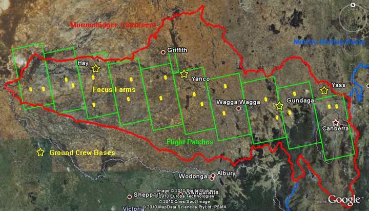 Source: GoogleEarth, accessed on 28th, Apr. 2010 (modified)
An overview of the AACES-1 campaign is provided in a KML file that can be opened by Google Earth software. All data collected during the AACES-1 can be downloaded via the Download Centre. AACES-1 field campaign schedule
Reconnaissance (Recon.):
Surface roughness measurements, gravimetric soil sampling, set up/removal of temporary monitoring stations Sampling: HDAS soil moisture measurements, LAI and ASD measurements, destructive vegetation/dew sampling, classification of land cover/canopy height/surface rock cover |
||||||||||||||||||||||||||||||||||||||||||||||||||||||||||||||||||||||||||||||||||||||||||||||||||||||||||||||||||||||||||||||||||||||||||||||||||||||||||||||||||||||||||||||||||||||||||||||||||||||||||||||||||||||||||||||||||||||||||||||||||||||||||||||||||||||||||||||||||||||||||||||||||||||||||||
|
Created: January 2010 Last Modified: August 2010 Maintainer: YE Nan, Ye.Nan@monash.edu |
